 |
|
The data on this web site are organized into convenient tables for easy access. The hydrographic data for all oceans are divided as follows:
Note: Data released after the publication of the first WOCE CD ( 12 February 1998 ) are highlighted in garnet and gold.
| Data Tables |
Ship List : A list of ships whose data appears on this server. |
Pacific Ocean One-time Data : One time lines are hydrographic sections completed only once during the WOCE field phase. Frequently these lines are completed in segments (north,south,etc.) and, on occasion, are completed more than once. |
Pacific Ocean Repeat Data : Repeat lines are hydrographic sections or regions upon which multiple cruises are completed during the WOCE field phase. The frequency (monthly,biannual,etc.) of the cruises varies. |
Pacific Ocean Time Series Data : Time series hydrographic cruises are similar to repeat cruises, except measurements are collected at a specified position in the ocean. Vessels normally drift for several days near the time series site. |
| Atlantic Ocean : Table of one-time, repeat, and time series hydrographic cruises for the Atlantic Ocean. |
| Indian Ocean : Table of one-time, repeat, and time series hydrographic cruises for the Indian Ocean. |
| Southern Ocean : Table of one time, repeat, and time series hydrographic cruises for the Southern Ocean. |
The data tables contain eight columns of information for each
hydrographic section. The first five columns of the tables contain:
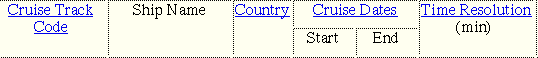
| Cruise track code | An alphanumeric code that identifies the WOCE hydrographic section. The cruise track code is defined in the format documentation or by clicking the header in any of the data tables. For your convenience, we have provided cruise maps for each quality controlled hydrographic section. These can be accessed from our map page or from the data page for an individual cruise. The cruise maps are constructed using only correct ship position data. Missing values and erroneous positions are removed and may result in breaks in the cruise track. |
| Ship name | Full name of vessel provided to DAC |
| Country | Country code. Values can be decoded using a table
accessible by clicking the column header on any data
table. |
| Cruise dates | Start and end dates of data available for the cruise. Often
these dates are not identical to the date of a specific
WOCE hydrographic section. When available, we provide the
entire port to port data set for a vessel. |
| Time resolution | The time difference (in minutes) between successive
observations in the data set. This ranges from 1 to 360
minutes depending on the data source. |
The last three columns contain:
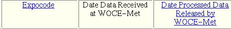
| Expocode | A unique alphanumeric code for a cruise provided by the WOCE Hydrographic Project Office. This code can be used to match meteorology data to other WOCE data types. |
| Date received | The date the meteorological data arrived at WOCEMET. Blanks in this column indicate that the meteorological data for that section has not arrived at WOCEMET. |
| Date released | The date that the final quality controlled version of the meteorological data was released to the WOCE community. The data release always includes a report on the quality of the data. By clicking highlighted dates in this column you can access the quality controlled data, cruise track maps, and documentation for that hydrographic section. When N/A appears in this column that means WOCEMET has determined that no meteorological data are available for that hydrographic section. The column is left blank when the data for the cruise has not yet completed quality control. We urge you to register with WOCEMET to receive updates when new data sets become public. |